View Larger Map
We were attacked Mosquito last night, by 6:50am to get up, loading all kinds of objects into the car, then 9:40 left
camp ground . We drove on the famous Highway I-90, we will be traveling on the
road for whole day, the speed limit is
80 miles per hour (108 km). Now we are traveling in southeastern Minnesota,
where mainly in agriculture and forestry, the beautiful scenery along the high way
all over the farm, the residents are locals, more reserved the local Americans
style.
Lunch time We went off the highway to a local PIZZA house
for lunch, thin PIZZA—too delicious, we had all the food eliminated.
With the disappearing farmland pasture, gradually emerging
is a vast expanse of desert. 17:22PM, we finally came to our first national park
on this trip - Badlands Nation Park. The park is located in the southwest of
South Dakota, an area of 244,000 acres (990 square kilometers), there are
many mounds, spikes and grass. It is already evening time, but the sun is still
burning hung in the air, the thermometer displays outdoor temperature of 93
degrees Fahrenheit (34 degrees Celsius). Parks everywhere loess hills of sand
and gravel, the mountain yellow mixed with a layer of layer of red, stone was
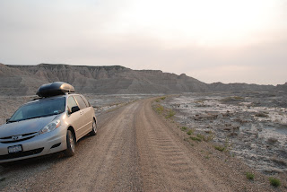
sediment, barren, far aloft looked like pot boiled dry seawater marine. The road
to sheep mountain table is very tough, but offering a great view.
Tonight's camp is located in the Black Hills National Forest-
KOA campground, which is a famous chain camping agencies and facilities in good
condition, have a bath as well as laundry. We live in the tent area, one night
camping fee is $ 35. After we built our tent, Rachel lost one tooth by Daddy’s
help.
 |
| sheep mountain table - Bad lands National Park |
 |
| sheep mountain table road |


